Continental Divide Trail: Days 1-5
- May 3, 2024
- 17 min read
Updated: Apr 11
I realize that, as I embark on this journey, many if you may not actually be all that familiar with this hike. Unlike the Appalachian Trail, the birthplace of thru-hiking culture, the most popular U.S. thru-hike, the Continental Divide Trail boasts a less conspicuous reputation. The Appalachian Trail, the Pacific Crest Trail, and the Continental Divide Trail complete the U.S. Triple Crown of thru-hikes. The former two are well-known and popular, but the CDT is the grungy black sheep of the Triple Crown siblings.
The Continental Divide Trail is a 3,100(ish)-mile trail between Mexico and Canada, following the North American continental divide. On one side of the line, all water flows into the Pacific Ocean; on the other side, all water flows into the Atlantic (and, in Canada, into the Arctic as well). The states I will traverse are New Mexico, Colorado, Wyoming, Idaho, and Montana.
The "ish" mileage comes from the numerous ways that one can get from border to border. This trail has many "alternates," and it's widely considered a "choose your own adventure" trail. I am going to offhandedly estimate that our trail journey will encompass about 2,700 miles.
I'll be doing this trail with my friend Katie, who I met on the Colorado Trail. I will often refer to the two of us in the first person plural, but this journal is a reflection of my thoughts alone.
As always, thank you for following along!
Day 1
Miles hiked today: 17.6
Total miles hiked on trail: 17.6
The beginning never feels real.
Today began in the town of Lordsburg, New Mexico with a 5:00 a.m. wakeup call, a mile-long walk from the EconoLodge to a shuttle stop, and a 3-hour drive to the Mexican border. Fourteen of us clamored into three pickup trucks and pretended to engage in conversation while wading in the confusing pools of our own brains. Katie (or rather Double Dip; I suppose we will revert to trail names now, and as a reminder, mine is Wrong Way) noted that I seemed really quiet in the car. I didn't really want to talk to people. I just wanted to start hiking so that it could begin to feel like we weren't just on a road trip through New Mexico.

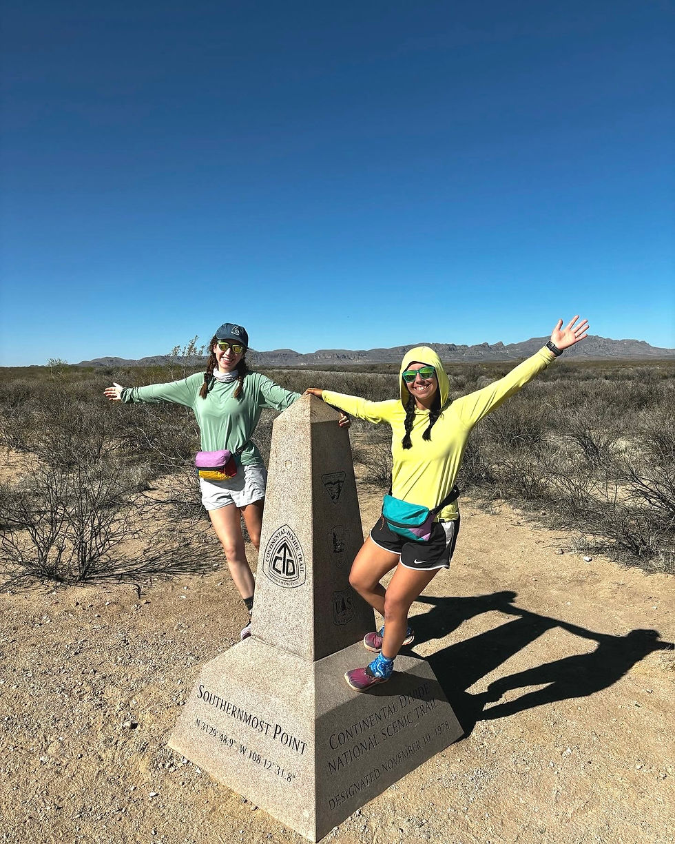
After taking photos at the terminus at Crazy Cook Monument, just before 10:00 a.m., the journey really began.

There were several times today where I had the thought, "Damn. I really am just out here doing this for the next 5 or so months." Sometimes, that thought brought the most manic grin to my face. Other times, it made me really question why I can't be content with like... yoga or something.
The trail starts in the full-on desert. I mean cacti and other pointy shrubbery, lizards, heat, dust, sun exposure, no water. The desert is not your friend. Everything wants to poke you, pinch you, or bite you. There's nowhere to hide from the sun. There's nothing to quench your unquenchable thirst. It didn't help that not a single cloud graced the cerulean sky, and there was rarely so much as a whisper of a breeze today. The still air made the heat even more suffocating.


The first reliable on-trail water source is a Continental Divide Trail Coalition-provided water cache: six beautiful 6-gallon jugs lined a metal box 14 miles in, but nothing was really available before then except a hard-to-access off-trail source only 2 miles prior. The options were to either start with too little water or carry an excess, both of which are uncomfortable for different reasons. I won't embarrass myself by sharing how little I started with. I would guess it was in the high 80s to mid 90s from 10:30 until 4:00, and even with a sun-protective hoodie and a UPF 50+ umbrella, I definitely felt the heat. I was unbelievably grateful to get to the water cache a little after 4:00.
Already, this trail doesn't feel beginner-friendly. This trail assumes that you can do 12-14 miles in a single afternoon push. You just have to, because of water. There were a few times I felt so hot and dehydrated, I felt nauseous and lightheaded. And there wasn't really an out. I just had to hike until the water cache. The next few days' miles will also be dependent on water availability.
The general consensus is that the best move is to take frequent breaks in whatever scraps of shade you can find in those oppressive afternoon hours. I was too water-motivated to stop much, but the 2.5-hour break at the water cache was the most soul-replenishing experience of my life. Since we didn't start hiking until almost 10:00 this morning, we didn't get those precious sunrise hours to get in miles. We talked to Will from Australia, Spruce from the Czech Republic, and Red Panda from San Diego. Made a nice dinner, took off our shoes, stretched as much as we could before setting back off toward our intended campsite.
The best part of the day, aside from seeing the southern terminus, was the last 3 miles at dusk. Double Dip and I actually hiked together for that part, unlike the rest of the day where we only caught up at breaks. The evening temperature was SO refreshing after the sweltering heat of the day, and I swear, New Mexico is going to have the best sunsets.

We rolled up to camp as it was getting dark, so we couldn't stay up and chat. Set up your shelter, inflate your sleeping pad, and go to bed.
Today is the two month anniversary of my wedding. I will never fail to feel so immensely lucky to have a partner - a husband, which still feels wild to say - who supports me as much as he does. Mitch, whose response to me saying I was going to do this trail was "I'll miss you, but what can I do to support you?", was not an easy person to leave behind. He drove me to New Mexico, stayed with me in Silver City and then Lordsburg, and then drove to a home I won't see for 5 or more months. I'm glad I'll see him in a few weeks.
Day 2
Miles hiked today: 21.7
Total miles hiked on trail: 39.3
I would like to reiterate that this is not fun. Yet.
My left hip, or maybe glute, has been bothering me a bit since before the trail. I'd hoped I'd rested it enough before coming out here, but evidently that wasn't the solution, because it's been twinging all day, and I had to take pauses every few miles to stretch it out. Also, my feet are so sore. Also, my shoulders ache. I know these maladies will go away over time, but as of now, my whole body hurts to at least some degree.
The most alarming way in which this has differed from the beginning of the Appalachian Trail is the total inability to reduce your mileage to an acceptable beginning pace. In an ideal state, we'd be going 15-18 miles per day (while excruciatingly hot, the terrain is overall very friendly, and we've gained and lost very little elevation), but our biggest factor for choosing camp is water availability. Shockingly, the desert does not provide as many sources as the forests out east do. All of the water we've gotten so far has been from a cache left by the Continental Divide Trail Coalition (CDTC) or a water tank with a spigot on some cattle ranch; without those sources, there's no way we'd survive out here, and that sounds dramatic, but I'm being sincere. Anyway, today consisted of a 9 mile carry at the beginning followed by a 12 mile carry to the end. And you might be asking, "Why not do a 9 mile day and a 12 mile day?" To which I'll respond: I'm not planning on carrying twice as much food.
At the second water cache, we met Radar, a CDTC-affiliated trail angel who stocks 3 out of the 5 water caches along the stretch of trail between the terminus and the town of Lordsburg. Radar also stocks the cache boxes with sunscreen and hand sanitizer. Literally bless him. Whatever afterlife there may be, I hope he goes to the best place.

Double Dip and I slept in until 6:15. I know this doesn't sound like sleeping in, but when you're sleeping in a tent, and you don't have real protection from daylight, people tend to naturally wake up once the sun starts poking out. Sleeping in was a major mistake. Any hiking you can accomplish outside the hours of 10:00 and 4:00 is a gift, and we were foolish to squander that much of the morning. We were fortunate to have some cloud coverage and wind today, which was a luxury compared to yesterday's unobstructed sun exposure and still air, but it's still a desert, and it still gets hot as hell in the middle of the day.


At 14 miles in, we were able to take a break "in the shade," and by that I mean in a wash (which is a ditch that routes excess water, if there ever is water) with a few sparse trees overhead. It was far from comfortable, and with shade came some shrubs that were not thrilled at having to share space, nor we them, but we were at least off our feet and kind of out of the sun for a little.

The last 7 miles after our break were fairly uneventful, and at least a little cooler. The relief of hiking in more relaxed temperatures made the miles much more doable.
We got to camp with an hour until sunset. The water source at camp was a water tank with a spigot. The land surrounding the tank was littered with cow pies, and we saw a few cows while we set up our tents. The sunset was beyond beautiful.
Already, the cuticles on my fingers are splitting. The exceedingly dry air, plus the constant pulling out or putting in or handling of gear, has made many of my cuticles bleed. I know they'll keep slicing open at a faster rate than they can mend.
While we were setting up our tents, we were surprised to see a golf cart-looking vehicle roll up near us. We were worried it would be the rancher whose water tank we'd used telling us we weren't welcome to camp on their land. Instead, it was a border patrol agent checking on some activity "the cameras" had picked up. Evidently, he was looking for a group of three, and we -- Double Dip, Red Panda, and myself -- were a group of three. I have to assume the cameras in question are motion detectors or heat sensors because then he couldn't have seen exactly who we were, but it did make me feel deeply uncomfortable that we were maybe being monitored.
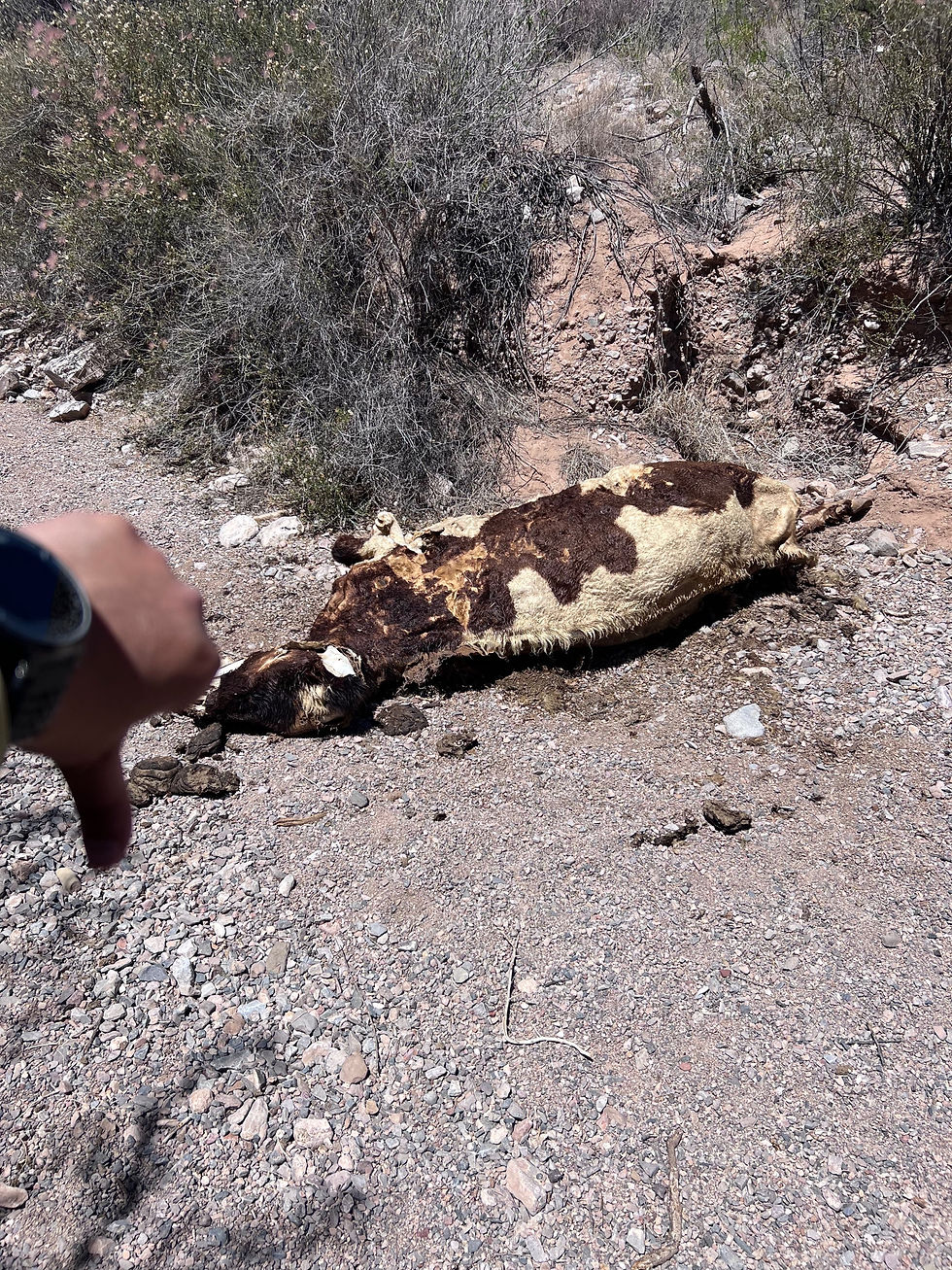
At the terminus, we were told that our satellite communicator SOS buttons would dispatch border patrol, who also act as the local search and rescue. They also told us that, regardless of our beliefs, if we saw anyone who was injured -- thru-hiker, day hiker, or migrant -- we were obligated to hit the SOS button. Being out here has made me think a lot about people choosing this route to enter this country. I don't care what you may believe, but after even two days out here, I know with the utmost certainty that anyone who resorts to this is at their last possible, most desperate option, and I hate to think about what they're running from that could possibly be worse than this. We have sun-protective gear, water caches, and an extensive map app to help us get through, frankly, alive. They have none of that. The fact that there isn't a 100% fatality rate for migrants crossing the border like this is unbelievable to me. It makes me sick that we aren't doing more to help, because many of these people are most certainly dying out here. If the constant barrage of bleached cattle bones is any indication, this is no place for human beings, either.
Day 3
Miles hiked today: 18.8
Total miles hiked on trail: 58.1
I think we finally figured out how to make this section bearable. That, or maybe today's been consistently windy enough that we don't notice that it's still sunny and exposed. Or both.
Last night, Double Dip and I decided we'd set an alarm so we could aim for a 6:00 a.m. departure so we could get in some morning miles before it got too hot. We left around 6:15 and did about 6 miles before taking a break at the water cache. The morning miles flew by, especially when we didn't fear withering away. We spent more time climbing over and down rolling hills than before, and it felt good to break up the monotony of flat.

Our first water break at the third water cache was long. It's hard to pass up clean, easy water, and putting on shoes after taking them off to air out your feet is an impossibly demanding task. We only had 5 miles until the next water source, so it was an easy carry this time.
I think what's made the past few days so challenging is it's solely been about survival, not enjoying new experiences or savoring any views. The desert doesn't want us here any more than we want to be in it. Every decision - when we wake up, how many miles we hike, when we take a break - is determined by water availability and heat mitigation. There is little joy in basic survival.
We took two more breaks today: one at a water tank and one under the glorious shade of a large juniper tree. We stayed at the water tank in the shade for a little over an hour, filling and refilling our water vessels while water was available, before hiking just 2 miles and finding not just a tree, but the tree. We sat under its protection for almost 3 hours before moving on. We didn't really do anything of note. It just felt great to be out of the sun and wind for a little.

Just 5 more miles and we were home free, where we camped at the fourth water cache. The wind felt so nice while we were hiking, but it became more problematic in the evening. It was hard to light our stoves to make dinner without being blown out. Double Dip and I both use trekking pole tents, which rely on our trekking poles and tent stakes to hold a pitch, and it was physically impossible to put them up with the ugly combination of loose ground and aggressive wind, so we both had to cowboy camp. I like cowboy camping by choice, but it was annoying to be forced into it.
We ate a bad-mood dinner with Red Panda and Will. Red Panda is in his 50s and has thru-hiked the Pacific Crest Trail. He's very kind, but he can be a bit competitive about things that I don't enjoy making into a competition (like who is suffering the most, who is the most scratched up, etc.). I will admit that I envied his freestanding tent tonight. Will is between Double Dip's age and mine, and our hiking styles seem to be pretty similar. He's from Australia, and I hope he's around us long enough for me to adopt things like "I reckon" and "mate" into my everyday vocabulary.
I'm grateful for my astronaut helmet-looking quilt hood attachment; I think it's my best chance at being comfortable tonight.
Day 4
Miles hiked today: 19.7
Total miles hiked on trail: 77.8
I'm sure this will come as an absolute shock, but I had a hard time sleeping last night. The worst part is, I think it's the best sleep I've gotten on trail so far. But I was undeniably awake by 5:00, and I was out of camp by 5:30.
I had to use my headlamp for the first mile, and I definitely got a little lost for a second there, but it honestly felt really good to just crank out some miles in the early morning. I love watching the light fade from navy to lavender to gold. I love the solitude and not feeling like I have to catch up or wait for anyone, just to be on my own schedule. So even though I would have appreciated a little extra sleep, it was nice to have the morning miles to myself.
Double Dip and I planned the majority of our day around a long break at the water tank 12 miles in. There were other water sources between caches 4 and 5, but the tank was by far the best one. I did notice that a covered trough about 4 miles in was reported to be "acceptable," so I decided to fill a half liter there. After moving some green floaters out of the way, it was quite clear and tasted ok! I'll have to get used to those after Lordsburg. Really hoping for more like the one at 4 miles in and not the one at 10 miles in, which I absolutely did not filter from.


Several times before my first break, I got off-trail. I'd be following the trail, what was an obvious foot path with signage, and I'd keep following it, and after realizing I hadn't seen a sign in awhile, I'd check my map and see I was a quarter mile off, never having seen an intersection or a place to stray from the trail. Fortunately, in cow pastures, I don't feel bad trampling plants to get to my desired location, as I'm sure many cows before me and many after me will be stomping away on the same spot.

I spent a few miles talking with Hiker Greg, who's going for his Triple Crown. He's hiked the Appalachian Trail at least four times, and a buddy of his convinced him to go for the others. We reminisced about Katahdin, and by the time we took a break at 9 miles in, we were both crying. I'm sure this northern terminus will be special and emotional, but Katahdin was pure magic.
After 9 miles, I took an hour-long break. I decided to pop the blister on the pad of my left foot that's been developing for the last few days. I can usually catch a hot spot before it develops into a blister, but this one was in such an inconvenient spot, there was nothing I could do. Could be worse; Double Dip's feet are absolutely covered in tape. Everyone has foot maladies from all the sand and dust getting into our shoes; even with long socks and protective gaiters, the small particles find their way in. Anyway, my Swiss arm knife was too dull to do the job, so I had to use the scissor attachment to cut it open. (I sterilized them before and after, don't worry.) Walking on it hurt the remainder of the day, and I think it was from the cutting more than the popped blister.
After a fairly quick 3 miles, we got to the water tank. A bunch of us took a long break there, hard-pressed to abandon water. Our campsite was going to be the last water cache, another 8 miles away. Best stay awhile and wait out some of the heat. I wish it weren't so windy so we could play some cards!
The remaining miles of the day alternated between impossible-to-lose dirt road and impossible-to-find "trail." We all got off-trail in these miles numerous times, forever grateful for the FarOut app for helping us find our way back to whatever trail they claim to have set out for us. "Trail confusion" seems to be the theme of the day.
After what seemed like an eternity, we got to camp at the final water cache. Water sources from here on out are going to look a lot more like the first trough today (and hopefully not at all like the second). It's still windy, and some people were still unable to pitch their tents as a result. I got mine up, but I know it's going to flap like crazy all night.
Tomorrow, we'll be in Lordsburg. Double Dip and I are planning on hiking the 7 miles into town, staying most of the day, and hiking out in the evening. We'd love to find a place to shower and do laundry -- seriously, I can make a whole new desert with all the grit on my body and clothes -- so we may bum off of some friends who are staying overnight.
I planned my food a little too well for this stretch. I didn't go hungry, but I have absolutely nothing left in my food canister except my breakfast. Gonna try to overdo it a bit for this next resupply.
Day 5
Miles hiked today: 12.3
Total miles hiked on trail: 90.1
Today was our first town day! We didn't stay overnight, but it was good to be back in Lordsburg for a few hours.
We only had 7 miles to hike between the campsite and town, so we let ourselves sleep in a bit before making our way there. We all woke up with sore throats and sniffly noses from poor sleep. It was sooo windy all night, and our tents, no matter how good, no matter how well-pitched, can't withstand heavy wind without noisy flapping. We also have been breathing in all the dust the wind blew into our tents, so that doesn't feel too good, either.
Usually, it's been warm enough after the sun comes out to hike without a fleece layer, but we all kept ours on for the first several miles. The wind and chill did not let up for a long while.
The first 4 or 5 miles were so peaceful - just gentle rolling hills, easy ups and downs, more dirt than sand, more green than brown. Eventually, you could see the town. I hate being able to see my destination from so far away! It never feels like it's getting closer. Instead of being plopped into the town center, the trail dropped us off on the road outside of town, and the road and town sidewalks actually were the trail itself, so getting to town was just following the trail.
Lordsburg has a reputation on the CDT for being sketchy. I want to dispel that notion as much as possible. Maybe it's because the people in town are more familiar with the hiking trail that runs through it, but I never once felt unsafe or unwelcome. Many passersby asked me about my hike, genuinely hoping for positive responses. Beyond just having all the amenities a hiker needs - lodging, resupply options, places to shower and do laundry - I'd say Lordsburg was a genuinely GOOD trail town, with genuinely good people! But none as good as Felicia.
Felicia is new in the trail angel community, but she is as close to an angel as this world has seen. She was born and raised in Lordsburg, and she spent many of her teen years homeless, living at that time in Aurora, Colorado. Coincidence would have it that she attended the very high school I recently taught at. She went to college for social work and eventually moved back to Lordsburg because she felt called to help her hometown. She is currently an art teacher, and maybe I would have even liked art class if she were my teacher.

Felicia's mantra is "Be unreasonably kind," and she lives up to that in everything. We were hoping to just have a place to shower and do laundry, but she made us breakfast burritos and chilaquiles. She set out blankets so we could all nap, even offering her own bed (though none of us took it). She said we could use her car if we wanted to go to the neighboring town for better food options (again, none of us took it, but name one person who would willy nilly let strangers borrow their car for the afternoon). She made us all tea. She said she knew what she wanted when she was homeless, and even though our "homelessness" is different, it's all what we wanted, too. And you know she extends the same egregious kindness to her students. She brings them breakfast. She buys all her art and classroom supplies. She gives them a safe and comfortable space. She deserves the same kindness, and it would mean a lot if you would consider donating to her Amazon Wishlist.
After resupplying at the Dollar General, we grabbed dinner before heading back out to the trail. Double Dip, Will-without-a-trail-name, and I had heard a lot about the whole fried fish, so we each got one, which we demolished on site, and a large horchata, which I ended up taking to-go. GREAT for the stomach and soul, but maybe not the best move for the road walk out of town (nowhere to hide means nowhere to do ya business). Within a quarter of a mile of getting off the road, as soon as I saw a large enough bush, I went for it. Not much more primal than that. I also now have to carry the large to-go cup in my trash bag until Silver City.

One notable part of this evening's hike out was that it was our first barbed wire fence that didn't have a gate or stile. The trail crosses many barbed wire-protector boundaries, and the CDTC has been working really hard to put in easier entry/exit points. Hikers used to have to shimmy their way under barbed wire fences fairly often, but this was our first one. I kinda wish it didn't feel so fun?
Once off the road, the trail turned into very confusing cow pastures. The trail basically ceased to be a trail, but rather a series of sign posts, and you just got there however you could.
Double Dip and I did our best to pitch our tents in the sandy soil with no rocks to assist. Not our best work, but it'll have to do.


Comments